Stórurð
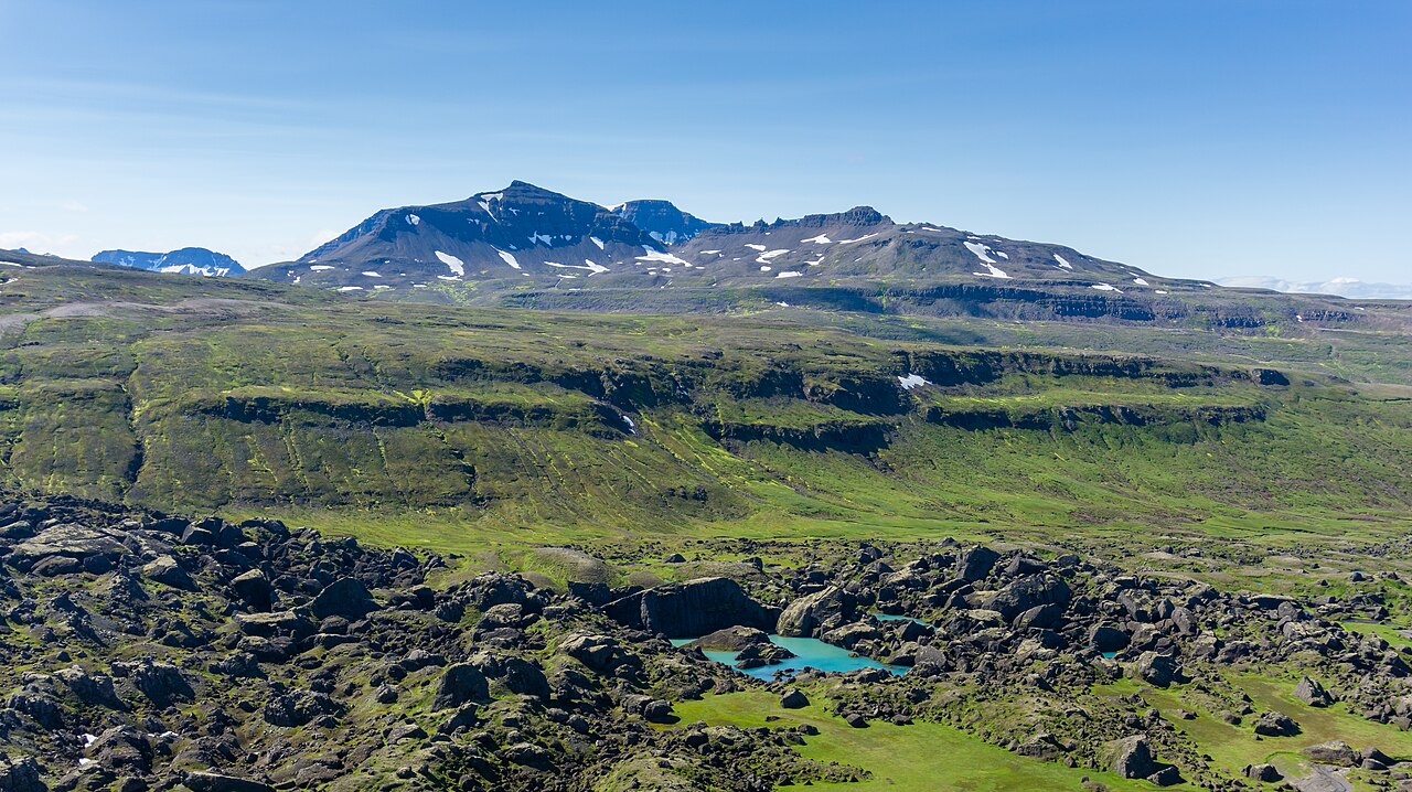
An 18 km loop into Stórurð, a hidden basin of giant boulders and green ponds beneath the jagged Dyrfjöll peaks.
- Distance
- 18 km
- Loop
- Time
- 5–6.5 hours
- Ascent
- 550 m
- Max 630 m
- Difficulty
- Challenging
The Stórurð hike is one of the finest day walks in East Iceland: an 18 km loop that climbs over moorland to a hidden basin of house-sized boulders, flat grassy lawns and still, blue-green ponds lying under the cliffs of Dyrfjöll. Expect 5–6.5 hours of walking with about 550 m of total ascent and a high point of roughly 630 m. The name means 'the great scree', and the scale of the rocks, dropped here by ancient glaciers and rockfalls, is hard to take in until you are standing among them.
The trail starts and finishes on Route 94, the road between Egilsstaðir and the village of Borgarfjörður eystri. It is waymarked, but long, exposed and rough underfoot in places, with boulder-hopping inside Stórurð itself and snow patches that can linger into July. It is rated challenging mainly for length and terrain rather than steepness. On a clear day it is unforgettable; in thick fog the featureless moor and boulder field make navigation genuinely difficult, so pick your day.
Highlights
- Giant boulders scattered across flat green lawns
- Turquoise ponds reflecting the Dyrfjöll cliffs
- Close views of the notched Dyrfjöll ridge, the 'door mountains'
- Wide moorland views toward Héraðsflói and Borgarfjörður eystri
- Relatively few people compared with South Iceland trails
The route
Route 94 to the Stórurð basin
From the car park the path climbs gradually across heath and stony moor, following marker posts toward the western flank of Dyrfjöll. The going is mostly steady with a few wet patches and stream crossings that are usually easy to step over. As you gain height the notch in the Dyrfjöll ridge comes into view, and the trail then drops into the valley below the cliffs where the boulder field begins.
Exploring Stórurð
Inside Stórurð the path weaves between enormous blocks of rock, some the size of houses, with patches of smooth grass and small ponds in between. Route-finding is helped by markers, but you will be stepping over and around rocks for a while, so take it slowly and keep an eye on the waymarks. This is the place for a long lunch stop, out of the wind among the boulders.
Return to the road
The loop leaves the basin by a different valley and climbs back over the moor before descending to Route 94, where the last 2.5 km or so follow the road between two trailheads back to the starting car park. The return over the moor feels long after the boulder field, and the last climb catches many people out. Keep some food and water in reserve, and if fog rolls in, stay strictly with the marker posts until you can see the road.
Getting to the trailhead
The trailhead is on Route 94 (Borgarfjarðarvegur), on the stretch between Egilsstaðir and Borgarfjörður eystri, with a small car park and information board. Allow roughly 40–60 minutes' drive from Egilsstaðir depending on conditions. Route 94 is now paved, but it crosses a mountain pass, so check road.is before setting out, especially early or late in the season. Stórurð has five marked approaches in all (two from Vatnsskarð, one from Njarðvík and two from Borgarfjörður eystri), and a shorter out-and-back of about 15 km is also possible. There is no practical public transport to the trailhead.
Where to stay
Borgarfjörður eystri, a small village known for its puffin colony at Hafnarhólmi, has guesthouses, a campsite and a café or two in summer. Egilsstaðir, the main town of East Iceland, has the widest choice of hotels, guesthouses, supermarkets and fuel, and makes an easy base if you are driving the region.
Best time to hike
The hiking season runs from June to September. Early June can still see deep snow in Stórurð and on the higher moor, and snow patches often last into July. Mid-July to late August usually gives the best conditions, with the ponds clear of ice and the lawns green. September is quieter, with autumn colours, but days shorten quickly and weather turns more often.
Safety
Stórurð is remote and much of the route is exposed moorland. Fog is common in East Iceland and can make the marker posts hard to follow, especially on the return. Watch your footing among the boulders, where a twisted ankle far from the road becomes a serious problem. Carry waterproofs, warm layers, food, water and a GPS track. Check vedur.is, leave a travel plan on SafeTravel.is, and call 112 in an emergency; mobile coverage can be patchy.
Plan & book
Book your Stórurð hike
 Camping
East Iceland Campsites
Campsites around Egilsstaðir and Hallormsstaður forest.
Tjalda.is directory
Guided tourEast Iceland Tours from Egilsstaðir
Stuðlagil, Hengifoss and the eastern fjords with a local guide.
Local operators1 day
Online booking opens soon. Press any button to get notified when it does.
Stórurð FAQ
How long is the Stórurð hike?+
The Stórurð loop is about 18 km with roughly 550 m of total ascent and a high point around 630 m. Most hikers take 5–6.5 hours including a stop in the boulder field.
Is the Stórurð hike hard?+
It is rated challenging mainly because of its length, rough ground and exposure rather than steep climbing. Fit hikers with good boots handle it well. Beginners may find the boulder field and the long return tiring.
When is the best time to hike Stórurð?+
Mid-July to late August is usually best. In June and early July snow can still cover parts of the route and the ponds, and in September the weather and short days make an early start more important.
Is the Stórurð trail marked?+
Yes, the route is waymarked with posts, but markers can be far apart on the moor and hard to see in fog. Carry a map or GPS track as a backup.
Hike it with a private guide
Guided trips with a licensed Icelandic guide, including transport and huts.
Private guide requests are coming soon
We are lining up licensed local guides. Sign up and we will let you know as soon as you can request a tailored quote.